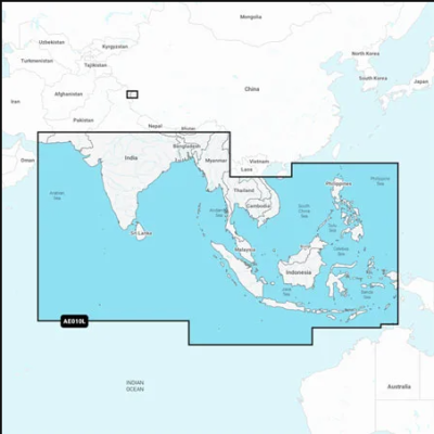
Close arrow_back
- menu title
-
Custom Menu
add remove
-
Navigation
add remove
-
menu title
add remove
-
menu title
add remove
-
menu title
add remove
-
menu title
add remove
-
menu title
add remove
- menu title
-
Custom Menu
add remove
- Navigation add remove
-
menu title
add remove
-
menu title
add remove
-
menu title
add remove
-
menu title
add remove
-
menu title
add remove
Mapa Navionics+ Wielka Brytania i Irlandia, jeziora i rzeki
Szczegółowa mapa głównych jezior i rzek Wielkiej Brytanii i Irlandii. Obejmuje Tamizę, Medway, Mersey, Avon i Tweed w Wielkiej Brytanii oraz rzekę Shannon w Irlandii. Mapa jeziora obejmuje Lock Ness, Loch Lochy i Lough Neagh w Wielkiej Brytanii.
Podobne z kategorii
Availability: 1 In Stock
Detailed coverage of the coasts of Norway and Sweden from Flekkefjord, Norway to Ystad, Sweden and the entire coast of Denmark. Coverage includes the Limfjord, the Kattegat, the Orosund, Læsø, Bornholm and Lakes Fryken, Siljan, Vänern, Vättern, Mjörn, Sommen, Nommen, and Bolmen in Sweden. Ports include Oslo and Kristiansand, Norway; Copenhagen and Aarhus, Denmark and Gothenburg and Malmö, Sweden.
Availability: 6 In Stock
Detailed coverage of the Mediterranean and Black Seas. Coverage includes the Azores, Madeira, the Canary Islands, Gibraltar, the Balearic Islands, Corsica, Sardinia, Sicily, Malta, Crete, Cyprus, the Dardanelles, the Bosporos, the Sea of Azov, the Dneiper River to the Kyivs'ke Reservoir, the Danube River to Passau, Germany, Lake Balaton, Lake Garda, Lake Como and Lake Maggiore. Ports include Cadiz and Barcelona, Spain; Monaco; Marseille and Toulon, France; Genoa, Naples, Taranto and Venice, Italy; Istanbul, Turkey; Odessa, Ukraine; Tunis, Tunisia and Algiers, Algeria.