Close arrow_back
- menu title
-
Custom Menu
add remove
-
Navigation
add remove
-
menu title
add remove
-
menu title
add remove
-
menu title
add remove
-
menu title
add remove
-
menu title
add remove
- menu title
-
Custom Menu
add remove
- Navigation add remove
-
menu title
add remove
-
menu title
add remove
-
menu title
add remove
-
menu title
add remove
-
menu title
add remove
Mapa elektroniczna Navionics+ Indian Ocean & South China Sea
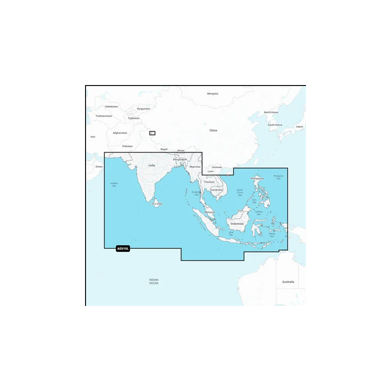
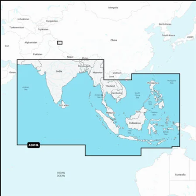
Coastal coverage of the South Asian coast and the Indian Ocean from Gwadar, PK to Da Nang, VN and the South China Sea. Includes India, Ceylon, Bangladesh, Myanmar, Thailand, Malaysia, Singapore, Cambodia, Indonesia, Brunei, the Philippines, the Andaman and Nicobar Islands, the Cocos Islands, Christmas Island, and the Maldives. Lakes Pangong and Spanggur are also covered.
Mapa wybrzeża Azji Południowej i Oceanu Indyjskiego od Gwadaru w Pakistanie do Da Nang w Wietnamie i Morza Południowochińskiego. Obejmuje Indie, Cejlon, Bangladesz, Myanmar, Tajlandię, Malezję, Singapur, Kambodżę, Indonezję, Brunei, Filipiny, Wyspy Andamańskie i Nikobarskie, Wyspy Kokosowe, Wyspę Bożego Narodzenia oraz Malediwy. Objęte są również jeziora Pangong i Spanggur.
Podobne z kategorii
Availability: 6 In Stock
Coastal coverage of the coast of Africa from Tripoli, Libya thru the Red Sea and around the Cape to Dakar, Senegal including the Suez Canal and the Levant, the coast of the Arabian Peninsula, the Persian Gulf, Madagascar, Socotra, Zanzibar, Reunion, Mauritius, the Seychelles, the Comoros, the Prince Edward Islands, Tristan de Cunha, St Helena Island, Ascension Island, the Cape Verde Islands, Malta and Cyprus. Coverage of ports such as Alexandria, Egypt; Djibouti; Manama, Bahrain; Dubai; Cape Town, South Africa and Lagos, Nigeria are included.
Availability: 6 In Stock
Mapa wybrzeża wschodniej Azji — od Władywostoku w Rosji do delty rzeki Mekong. Mapa obejmuje Wyspy Japońskie, Półwysep Koreański, Tajwan, Brunei i Filipiny oraz porty w Szanghaju, Dalian, Hongkongu i Pusan.
Availability: 7 In Stock
Detailed coverage of central and western Europe. Coverage includes the European coast from the Szczecin Lagoon to Monaco; the Azores; Madeira; the Canary Islands; the Balearics; Corsica and Sardinia; Gibraltar, the English Channel; the Channel Islands; the IJsselmeer; the rivers of France, Germany and the Low Countries; Lakes Maggiore, Como, Garda, Geneva, Constance and Balaton.
Availability: 6 In Stock
Detailed coverage of the Baltic Sea and lakes of Scandinavia and Poland. Coverage includes the Gulfs of Bothnia, Finland and Riga; the Masurian Lakes in Poland, the Szczecin Lagoon, Lake Peipus; Lakes Mjøsa, Bandak and Norsjø in Norway; Lakes Vänern, Vättern, Siljan and Storavan in Sweden; Inarijarvi, Miekojarvi, Simojarvi, and Kiantajarvi in Finland among many others. Ports include Oslo, Norway; Malmo and Stockholm, Sweden; Oulu and Helsinki, Finland; St Petersburg and Kaliningrad, Russia; Gdansk, Poland.
Availability: 6 In Stock
Detailed coverage of the UK, Ireland and the North Sea and English Channel coasts. Coverage includes the Shetland Islands, Orkney Islands, Isle of Man, Isle of Wight, the Isles of Scilly, the Channel Islands, the Thames River, the IJsselmeer, the Waddenzee and the Kiel Canal. Ports include London, Liverpool, Southampton, Edinburgh and Belfast, UK; Dublin and Cork, Ireland; Brest, Le Havre, Calais and Dunkirk, France; Antwerp, Belgium; Amsterdam and Rotterdam, The Netherlands; Bremerhaven, Hamburg and Kiel, Germany.
Availability: 6 In Stock
Detailed coverage of the entire U.S. coasts, lakes, rivers and inland waterways, plus Alaska and Hawaii. Canada coverage of coastal British Columbia, the Great Lakes, the St. Lawrence Seaway, New Brunswick and Nova Scotia. Coverage includes Bermuda, the Bahamas, Baja California, the Gulf of California, Johnston Atoll and Palmyra Atoll/Kingman Reef.