Zamknij arrow_back
- Nowości
-
Mapy i publikacje
add remove Mapy papierowe add removePublikacje papierowe add remove
-
Nawigacja
add remove Zegary add removeBarometry add removeTermometry , Higrometry, Barografy add removeAreometry (Densymetry) add remove
-
Sygnalizacja
add remove Lampy Nawigacyjne, Szperacze add removeŻarówki add removeLatarki add removeZnaki dzienne add remove
-
Środki ratunkowe
add remove Kamizelki add removeTratwy add removeKombinezony ratunkowe add removePirotechnika morska add removeKoła, Pławki, Tyczki add removeUprzęże, Linki, Taśmy Bezpieczeństwa add removeReflektory radarowe add removeBosaki, Wiosła add remove
-
Elektronika morska
add remove Radiotelefony add removeOdbiorniki Pogody add removePLB / AIS MOB, OLAS add removeRadiopławy, Transpondery add removeWiatromierze add removeAkcesoria add remove
-
Sprzęt pożarowy
add remove Akcesoria add remove
-
Wyposażenie pokładowe
add remove Drabinki Pilotowe, Ewakuacyjne add remove
- Nowości
-
Mapy i publikacje
add remove Mapy papierowe add removePublikacje papierowe add remove
- Nawigacja add remove
- Sygnalizacja add remove
- Środki ratunkowe add remove
- Elektronika morska add remove
- Sprzęt pożarowy add remove
-
Wyposażenie pokładowe
add remove
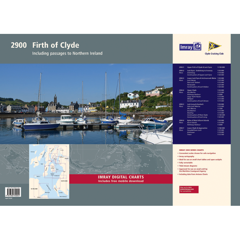
2900 Firth of Clyde Chart Pack
Mapa imray2900 Firth of Clyde Chart Pack jest zbiorem 16 map żeglarskich pokrywających obszar zatoki Firth of Clyde w Szkocji. Mapy są wykonane z trwałego i wodoodpornego materiału, a ich skala jest dostosowana do potrzeb żeglarzy. Mapy zawierają informacje o głębokościach, znakach nawigacyjnych, przepływach pływowych, portach i marinach. Mapa imray2900 Firth of Clyde Chart Pack jest niezbędnym narzędziem dla każdego, kto chce odkrywać ten malowniczy region żeglugi.
Zawiera plany:
1. Firth of Clyde (1:210 000)
2. The North Channel (1:210 000)
3. Aisla Craig to Ayr (1:75 000) includes plans Girvan (1:6000), Ayr (1:10 000)
4. Ayr to Ardrossan (1:75 000) includes plans Troon (1:12 500), Irvine (1:17 500), Ardrossan (1:10 000)
5. Pladda to Lamlash Harbour (1:30 000)
6. South of Bute & the Cumbraes (1:30 000) includes plans MiIlport (1:15 000), Largs Yacht Haven (1:15 000)
7. Upper Clyde (1:50 000) includes plans Kip Marina (1:15 000), Rothesay Bay (1:10 000), Rothesay Harbour (1:5000)
8. Long Loch & Gareloch (1:50 000) includes plans Continuation of Long Loch (1:50 000), Continuation of River Clyde (1:100 000), Dumbarton (1:15 000), Bowling (1:15 000), Approaches to Rhu (1:15 000), Holy Loch Marina (1:12 500)
9. Kyles of Bute (1:30 000) includes plans Continuation of Loch Striven (1:30 000), Continuation of Loch Riddon (1:30 000), Port Bannatyne Marina (1:10 000), Burnt Islands (1:10 000), Caladh Harbour (1:10 000)
10. Inchmarnock Water (1:30 000)
11. Lower Loch Fyne (1:50 000) includes plans Portavadie (1:25 000), East Loch Tarbert (1:8000), Ardrishaig (1:10 000)
12. Upper Loch Fyne (1:50 000) includes plans Continuation of Loch Fyne (1:50 000), Loch Gair (1:25 000), Minard Narrows (1:25 000), Invaray (1:25 000)
13. Inchmarnock to Kilbrannan Sound (1:50 000) includes plan Loch Ranza (1:22 500)
14. Carradale to Sanda Island (1:75 000) includes plans Campbeltown Loch (1:35 000), Campbeltown Harbour (1:7500), Sanda Island (1:30 000)
15. Aisla Craig to Loch Ryan (1:75 000) includes plan Stranraer (1:12 500)
16. Belfast Lough to Carnlough (1:90 000) includes plans Carrickfergus (1:15 000), Bangor Bay (1:17 500)














 Cookies