Zamknij arrow_back
- Nowości
-
Mapy i publikacje
add remove Mapy papierowe add removePublikacje papierowe add remove
-
Nawigacja
add remove Zegary add removeBarometry add removeTermometry , Higrometry, Barografy add removeAreometry (Densymetry) add remove
-
Sygnalizacja
add remove Lampy Nawigacyjne, Szperacze add removeŻarówki add removeLatarki add removeZnaki dzienne add remove
-
Środki ratunkowe
add remove Kamizelki add removeTratwy add removeKombinezony ratunkowe add removePirotechnika morska add removeKoła, Pławki, Tyczki add removeUprzęże, Linki, Taśmy Bezpieczeństwa add removeReflektory radarowe add removeBosaki, Wiosła add remove
-
Elektronika morska
add remove Radiotelefony add removeOdbiorniki Pogody add removePLB / AIS MOB, OLAS add removeRadiopławy, Transpondery add removeWiatromierze add removeAkcesoria add remove
-
Sprzęt pożarowy
add remove Akcesoria add remove
-
Wyposażenie pokładowe
add remove Drabinki Pilotowe, Ewakuacyjne add remove
- Nowości
-
Mapy i publikacje
add remove Mapy papierowe add removePublikacje papierowe add remove
- Nawigacja add remove
- Sygnalizacja add remove
- Środki ratunkowe add remove
- Elektronika morska add remove
- Sprzęt pożarowy add remove
-
Wyposażenie pokładowe
add remove
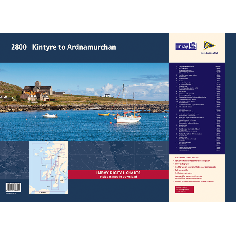
2800 Kintyre to Ardnamurchan Chart Pack Wiro Bound
Mapa imray 2800 Chart Pack - Kintyre to Ardnamurchan jest zbiorem 11 arkuszy map żeglarskich, pokrywających obszar od Mull of Kintyre do półwyspu Ardamurchan w Szkocji. Mapy są oparte na najnowszych oficjalnych badaniach batymetrycznych i zawierają szczegółowe informacje o portach, marinach i kotwicowiskach. Mapy są dostępne w wersji papierowej i cyfrowej i są zgodne z wytycznymi żeglarskimi Clyde Cruising Club dla tego rejonu. Mapy imray 2800 Chart Pack - Kintyre to Ardnamurchan są idealnym narzędziem dla żeglarzy, którzy chcą odkrywać jeden z najpiękniejszych akwenów na świecie.
Zawiera plany:
2800.1
Kintyre to Ardnamurchan (1:350 000)
2800.2
Mull of Kintyre (1:75 000)
Plans Campbeltown Loch (1:35 000), Campbeltown Harbour (1:7500), Sanda Island (1:30 000)
2800.3
Port Ellen to the Sound of Jura (1:75 000)
Plan Port Ellen (1:25 000)
2800.4
Sound of Gigha (1:25 000)
2800.5
West Islay (1:75 000)
2800.6
Sound of Islay to Colonsay (1:75 000)
Plan Scalasaig (1:12 500)
2800.7
Sound of Jura (1:75000)
Plans Craighouse Bay (Loch na Mile) (1:25 000), Loch Sween (Tayvallich) (1:25 000)
2800.8
Jura to Oban (1:75 000)
2800.9
Crinan and Loch Craignish (1:30 000)
Plan Crinan Approaches (1:10 000)
2800.10
Corryvreckan, Sound of Luing and Garvellachs (1:30 000)
2800.11
Cuan Sound and Loch Melfort (1:30 000)
Insh Island to Loch Feochan (1:30 000)
Plan Loch Feochan (1:30 000)
2800.12
Sound of Kerrera and Approaches to Oban (1:15 000)
2800.13
Firth of Lorn & Lismore (1:40 000)
2800.14
Loch Etive (1:40 000)
Plans Dunstaffnage Bay (1:15 000), Loch Etive Continuation (1:40 000)
2800.15
South Loch Linnhe and Loch Creran (1:40 000)
Plan Loch Creran Continuation (1:25 000)
2800.16
North Loch Linnhe, Loch Leven and Loch Eil (1:40 000)
Plans Loch Leven Narrows (1:15 000), Continuation of Loch Leven (1:40 000), Corran Narrows (1:15 000), Approaches to Corpach Sea Loch (1:20 000)
2800.17
Sound of Mull (1:40 000)
Plan Loch Aline (1:10 000)
2800.18
West Sound of Mull and Loch Sunart (1:40 000)
Plans Tobermory (1:20 000), Continuation of Loch Sunart (1:40 000)
2800.19
West Mull to Point of Ardnamurchan (1:75 000)
Plan Treshnish Isles (1:37 500)
2800.20
Coll and Tiree (1:75 000)
Plans Loch Eatharna (Arinagour) (1:17 500), Gott Bay (1:20 000)
2800.21
Ross of Mull and Iona (1:75 000)
Plans Bull Hole (1:25 000), Tinkers Hole (1:25 000)
2800.22
North of Coll Continuation (1:75 000)
West Loch Tarbert (1:30 000)
Jura Loch Tarbert (1:25 000)
Podobne z kategorii
Availability: Out of stock
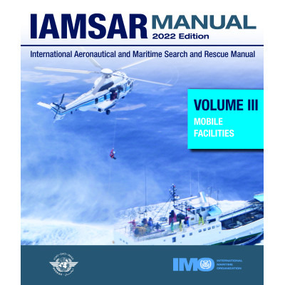
The *Mobile Facilities* volume is intended to be carried on board rescue
units, aircraft and vessels to help with the performance of a search,
rescue or on-scene coordinator function and with aspects of search and
rescue that pertain to their own emergencies.
A new edition of the IAMSAR Manual is published every three years. The
2022 edition includes amendments, adopted by the International Civil
Aviation Organization (ICAO) and approved by the Maritime Safety
Committee of the International Maritime Organization (IMO) at its 103rd
session in May 2021 by means of MSC.1/Circ.1640, which become applicable
Availability: Out of stock















 Cookies