Zamknij arrow_back
- Nowości
-
Mapy i publikacje
add remove Mapy papierowe add removePublikacje papierowe add remove
-
Nawigacja
add remove Zegary add removeBarometry add removeTermometry , Higrometry, Barografy add removeAreometry (Densymetry) add remove
-
Sygnalizacja
add remove Lampy Nawigacyjne, Szperacze add removeŻarówki add removeLatarki add removeZnaki dzienne add remove
-
Środki ratunkowe
add remove Kamizelki add removeTratwy add removeKombinezony ratunkowe add removePirotechnika morska add removeKoła, Pławki, Tyczki add removeUprzęże, Linki, Taśmy Bezpieczeństwa add removeReflektory radarowe add removeBosaki, Wiosła add remove
-
Elektronika morska
add remove Radiotelefony add removeOdbiorniki Pogody add removePLB / AIS MOB, OLAS add removeRadiopławy, Transpondery add removeWiatromierze add removeAkcesoria add remove
-
Sprzęt pożarowy
add remove Akcesoria add remove
-
Wyposażenie pokładowe
add remove Drabinki Pilotowe, Ewakuacyjne add remove
- Nowości
-
Mapy i publikacje
add remove Mapy papierowe add removePublikacje papierowe add remove
- Nawigacja add remove
- Sygnalizacja add remove
- Środki ratunkowe add remove
- Elektronika morska add remove
- Sprzęt pożarowy add remove
-
Wyposażenie pokładowe
add remove
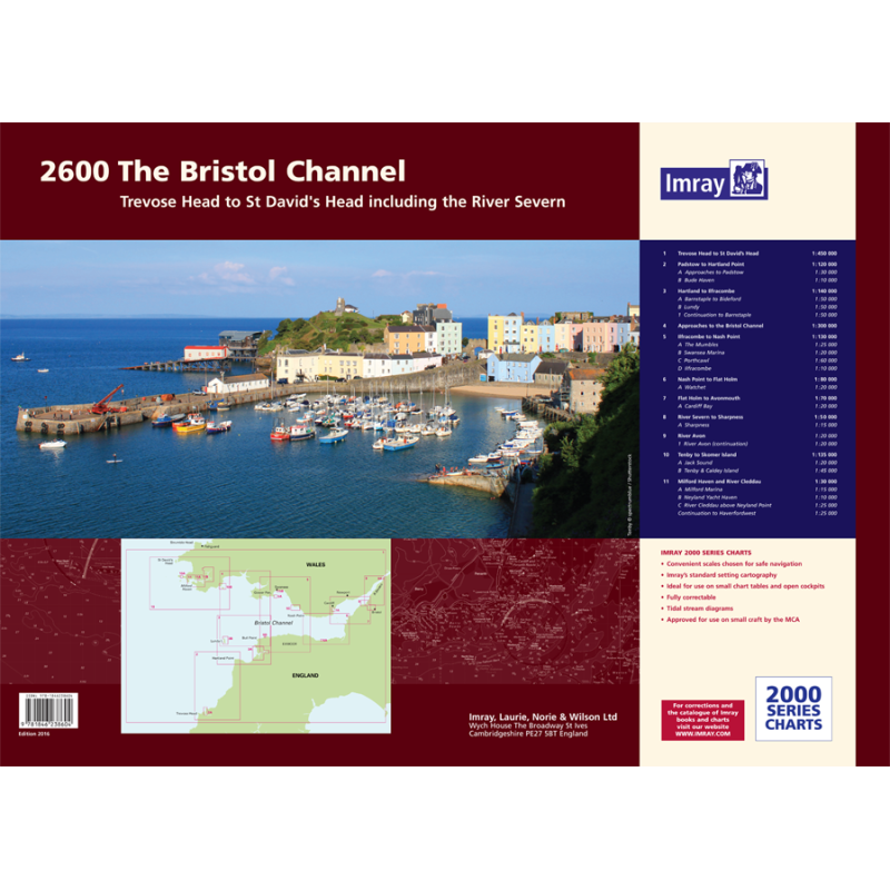
2600 Bristol Channel Chart Atlas
Mapa imray 2600 Bristol Channel Chart Pack jest zbiorem 14 map nawigacyjnych pokrywających obszar od Padstow do Sharpness. Mapy są wykonane z trwałego i wodoodpornego materiału, który zapewnia długą żywotność i łatwość użycia. Mapy zawierają aktualne informacje o głębokościach, znakach nawigacyjnych, przepływach pływowych i portach. Mapa imray 2600 Bristol Channel Chart Pack jest niezbędnym narzędziem dla żeglarzy i motorowodniaków żeglujących po kanale Bristolskim.
Zawiera plany:
2600.1 Trevose Head to St David’s Head 1:450, 000 WGS 84
2600.2 Padstow to Hartland Point 1:120, 000 WGS 84
Plans Approaches to Padstow, Bude Haven
2600.3 Hartland to Ilfracombe 1:140, 000 WGS 84
Plans Barnstaple to Bideford, Lundy, Continuation to Barnstaple
2600.4 Approaches to the Bristol Channel 1:130, 000 WGS 84
2600.5 Ilfracombe to Nash Point 1:130, 000 WGS 84
Plans The Mumbles, Swansea Marina, Porthcawl, Ilfracombe
2600.6 Nash Point to Flat Holm 1:80, 000 WGS 84
Plans Watchet
2600.7 Flat Holm to Avonmouth 1:70, 000 WGS 84
Plans Cardiff Bay
2600.8 River Severn to Sharpness 1:50, 000 WGS 84
Plans Sharpness
2600.9 River Avon 1: 20, 000 WGS 84
Plans River Avon (continuation)
2600.10 Tenby to Skomer Island 1:135 000 WGS 84
Plans Jack Sound, Tenby & Caldey Island
2600.11 Milford Haven - St Ann’s Head to Neyland Point 1:30, 000 WGS 84
Plans Milford Marina
2600.12 River Cleddau - above Neyland Point 1:25, 000 WGS 84
Plans Neyland Yacht Haven, Continuation to Haverfordwest

















 Cookies