Zamknij arrow_back
- Nowości
-
Mapy i publikacje
add remove Mapy papierowe add removePublikacje papierowe add remove
-
Nawigacja
add remove Zegary add removeBarometry add removeTermometry , Higrometry, Barografy add removeAreometry (Densymetry) add remove
-
Sygnalizacja
add remove Lampy Nawigacyjne, Szperacze add removeŻarówki add removeLatarki add removeZnaki dzienne add remove
-
Środki ratunkowe
add remove Kamizelki add removeTratwy add removeKombinezony ratunkowe add removePirotechnika morska add removeKoła, Pławki, Tyczki add removeUprzęże, Linki, Taśmy Bezpieczeństwa add removeReflektory radarowe add removeBosaki, Wiosła add remove
-
Elektronika morska
add remove Radiotelefony add removeOdbiorniki Pogody add removePLB / AIS MOB, OLAS add removeRadiopławy, Transpondery add removeWiatromierze add removeAkcesoria add remove
-
Sprzęt pożarowy
add remove Akcesoria add remove
-
Wyposażenie pokładowe
add remove Drabinki Pilotowe, Ewakuacyjne add remove
- Nowości
-
Mapy i publikacje
add remove Mapy papierowe add removePublikacje papierowe add remove
- Nawigacja add remove
- Sygnalizacja add remove
- Środki ratunkowe add remove
- Elektronika morska add remove
- Sprzęt pożarowy add remove
-
Wyposażenie pokładowe
add remove
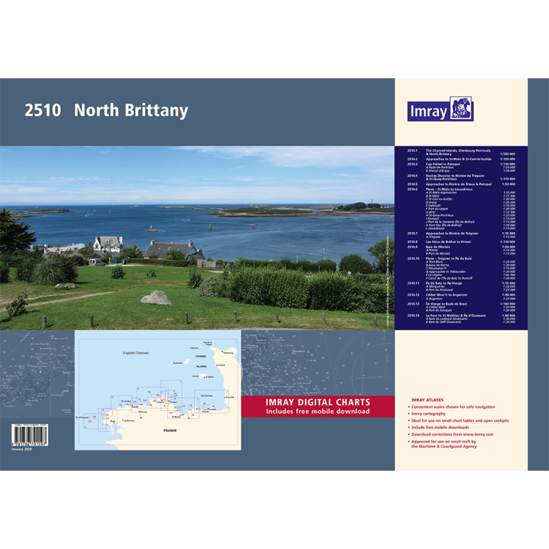
2510 North Brittany Chart Pack
Mapa imray 2510 North Brittany Chart Pack jest zbiorem 12 map nawigacyjnych pokrywających północne wybrzeże Bretanii od Pointe de Penmarc'h do Île de Bréhat. Mapy są wykonane z wodoodpornego papieru i mają format A2, zawierają informacje o głębokościach, znakach nawigacyjnych, pływach i prądach, portach i marina.
Zawiera plany:
2510.1 The Channel Islands, Cherbourg Peninsula & North Brittany
1: 550 000 WGS 84
2510.2 Approaches to St-Malo & St-Cast-le-Guildo
1: 120 000 WGS 84
2510.3 Cap Fréhel to Paimpol
1: 110 000 WGS 84
Plans Rade de Portrieux (1:50 000), Chenal d’Erquy (1:50 000)
2510.4 Roches Douvres to Rivière de Tréguier & St-Quay-Portrieux
1: 110 000 WGS 84
2510.5 Approaches to Rivière de Trieux & Paimpol
1: 50 000 WGS 84
2510.6 Plans – St-Malo to Lézardrieux
1: various WGS 84
Plans St-Malo Approaches (1:55 000), St-Malo (1:17 500), Saint-Cast-Le-Guildo (1:20 000), Erquy (1:20 000), Dahouët (1:10 000), Port du Légué (1:20 000), Binic (1:12 500), St-Quay-Portrieux (1:25 000), Paimpol (1:15 000), Port de la Corderie (Île de Bréhat) (1:15 000), Port Clos (Île de Bréhat) (1:10 000), Lézardrieux (1:15 000)
2510.7 Approaches to Rivière de Tréguier
1: 35 000 WGS 84
Plans Tréguier (1:15 000)
2510.8 Les Héux de Bréhat to Primel
1: 110 000 WGS 84
2510.9 Baie de Morlaix
1: 50 000 WGS 84
Plans Primel (1:15 000), Port de Morlaix (1:15 000)
2510.10 Plans – Tréguier to Île de Batz
1: various WGS 84
Plans Port-Blanc (1:25 000), Anse de Perros (1:30 000), Ploumanac’h (1:10 000), Approaches to Trébeurden (1:35 000), Le Léguer (1:42 500), Canal de l’Île de Batz to Roscoff (1:20 000)
2510.11 Île de Batz to Île Vierge
1: 75 000 WGS 84
Plans Moguériec (1:32 000), Port du Pontusval (1:25 000)
2510.12 L’Aber Wrac’h to Argenton
1: 40 000 WGS 84
Plans Argenton (1:25 000)
2510.13 Île Vierge to Rade de Brest
1: 100 000 WGS 84
Plans L’Aber-Ildut (1:25 000), Port du Conquet (1:20 000)
2510.14 Le Four to St Mathieu & Île d’Oussant
1: 80 000 WGS 84
Plans Baie de Lampaul (Ouessant) (1:30 000), Baie du Stiff (Ouessant) (1:30 000)











 Cookies