Zamknij arrow_back
- Nowości
-
Mapy i publikacje
add remove Mapy papierowe add removePublikacje papierowe add remove
-
Nawigacja
add remove Zegary add removeBarometry add removeTermometry , Higrometry, Barografy add removeAreometry (Densymetry) add remove
-
Sygnalizacja
add remove Lampy Nawigacyjne, Szperacze add removeŻarówki add removeLatarki add removeZnaki dzienne add remove
-
Środki ratunkowe
add remove Kamizelki add removeTratwy add removeKombinezony ratunkowe add removePirotechnika morska add removeKoła, Pławki, Tyczki add removeUprzęże, Linki, Taśmy Bezpieczeństwa add removeReflektory radarowe add removeBosaki, Wiosła add remove
-
Elektronika morska
add remove Radiotelefony add removeOdbiorniki Pogody add removePLB / AIS MOB, OLAS add removeRadiopławy, Transpondery add removeWiatromierze add removeAkcesoria add remove
-
Sprzęt pożarowy
add remove Akcesoria add remove
-
Wyposażenie pokładowe
add remove Drabinki Pilotowe, Ewakuacyjne add remove
- Nowości
-
Mapy i publikacje
add remove Mapy papierowe add removePublikacje papierowe add remove
- Nawigacja add remove
- Sygnalizacja add remove
- Środki ratunkowe add remove
- Elektronika morska add remove
- Sprzęt pożarowy add remove
-
Wyposażenie pokładowe
add remove
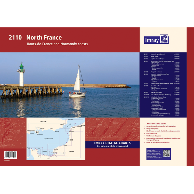
2110 North France Chart Atlas
Mapa imray 2110 North France Atlas jest zbiorem 12 arkuszy map morskich pokrywających wybrzeże północnej Francji od Dunkierki do Cherbourga. Mapy są wykonane z trwałego i wodoodpornego materiału, który nadaje się do użycia na pokładzie. Mapy zawierają szczegółowe informacje nawigacyjne, takie jak głębokości, światła, znaki i porty. Mapa imray 2110 North France Atlas jest niezbędnym narzędziem dla żeglarzy planujących podróż po kanale La Manche lub Morzu Północnym.
Zawiera plany:
2110.1 Eastern English Channel (1:600 000)
2110.2 Dover Strait (1:200 000)
2110.3 Cap Gris-Nez to Dieppe (1: 200 000)
2110.4 Nieuwpoort, Nord & Pas-de-Calais Plans
Plans: Nieuwpoort (1:30 000), Rade de Dunkerque (1:125 000), Dunkerque (1:25 000), Calais (1:20 000), Boulogne-sur-Mer (1:25 000), Étaples (1:75 000)
2110.5 Dieppe to Le Havre (1:200 000)
2110.6 Somme & Seine-Maritime Plans
Baie de Somme (1:75 000), Le Tréport (1:12 500), Dieppe (1:12 500), St-Valéry-en-Caux (1:12 500), Fécamp (1:12 500)
2110.7 Approaches to Le Havre & River Seine (1:60 000)
2110.8 River Seine Plans
Le Havre (1:12 500), River Seine to Tancarville (1:63 000), Honfleur (1:12 500)
2110.9 Baie de Seine (East) (1:155 000)
2110.10 Baie de Seine (West) to Cherbourg (1:155 000)
2110.11 Calvados & Manche Plans
Deauville/Trouville (1:15 000), Dives-sur-Mer (1:30 000), Ouistreham (1:25 000), Courseulles-sur-Mer (1:20 000), Arromanches (1:35 000), Port-en-Bessin (1:10 000), Grandcamp-Maisy (1:6000), Baie du Grand Vey (1:75 000), Saint-Vaast-La-Hougue (1:20 000), Barfleur (1:15 000), Cherbourg (1:40 000), Port Chantereyne (Cherbourg) (1:10 000), Omonville-la-Rogue (1:7000)
Podobne z kategorii
Availability: Out of stock
Edycja: 2022/23
Availability: Out of stock
Availability: Out of stock







 Cookies