Zamknij arrow_back
- Nowości
-
Mapy i publikacje
add remove Mapy papierowe add removePublikacje papierowe add remove
-
Nawigacja
add remove Zegary add removeBarometry add removeTermometry , Higrometry, Barografy add removeAreometry (Densymetry) add remove
-
Sygnalizacja
add remove Lampy Nawigacyjne, Szperacze add removeŻarówki add removeLatarki add removeZnaki dzienne add remove
-
Środki ratunkowe
add remove Kamizelki add removeTratwy add removeKombinezony ratunkowe add removePirotechnika morska add removeKoła, Pławki, Tyczki add removeUprzęże, Linki, Taśmy Bezpieczeństwa add removeReflektory radarowe add removeBosaki, Wiosła add remove
-
Elektronika morska
add remove Radiotelefony add removeOdbiorniki Pogody add removePLB / AIS MOB, OLAS add removeRadiopławy, Transpondery add removeWiatromierze add removeAkcesoria add remove
-
Sprzęt pożarowy
add remove Akcesoria add remove
-
Wyposażenie pokładowe
add remove Drabinki Pilotowe, Ewakuacyjne add remove
- Nowości
-
Mapy i publikacje
add remove Mapy papierowe add removePublikacje papierowe add remove
- Nawigacja add remove
- Sygnalizacja add remove
- Środki ratunkowe add remove
- Elektronika morska add remove
- Sprzęt pożarowy add remove
-
Wyposażenie pokładowe
add remove
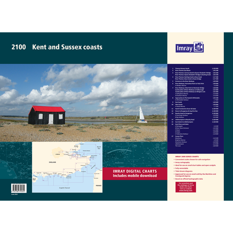
2100 Kent and Sussex Coasts Chart Atlas
Mapa imray 2100 Kent and Sussex coasts atlas jest zbiorem 17 arkuszy map pokrywających wybrzeża hrabstw Kent i Sussex w Anglii. Mapy są w skali od 1:120 000 do 1:6000 i zawierają najnowsze dane z UKHO oraz dodatkowe informacje ze źródeł Imray. Mapy są idealne dla małych jednostek pływających i uwzględniają najnowsze badania batymetryczne oraz rozwój portów w Dover i Calais. Mapy obejmują obszary od ujścia Tamizy po wschodnią część cieśniny Solent, a także rzeki Medway, Swale i Thames.
Zawiera plany:
2100.1
Thames Estuary South (1:120 000)
2100.2
River Thames Sea Reach (1:42 500)
2100.3
River Thames - Canvey Island to Queen Elizabeth II Bridge (1:42 500)
River Thames - Queen Elizabeth II Bridge to Barking Creek (1:42 500)
2100.4
River Thames - Barking Creek to Bow Creek (1:17 500)
River Thames - Bow Creek to Tower Bridge (1:17 500)
2100.5
Entrance to the River Medway (1:20 000)
2100.6
River Medway: Horseshoe Point to Folly Point (1:20 000)
Plan Whitton Marine (1:6000)
2100.7
River Medway: Folly Point to Rochester Bridge (1:20 000)
Continuation of River Medway to Holborough (1:25 000)
Continuation of River Medway to Allington Lock (1:25 000)
Plans Gillingham Marina (1:10 000), Chatham Marina (1:10 000)
2100.8
Approaches to The Swale & Whitstable (1:42 500)
Plan Whitstable Harbour (1:7000)
2100.9
East Swale (1:20 000)
2100.10
West Swale (1:20 000)
Plan Swale Marina (1:7500)
2100.11
North Foreland to Dover & Calais (1:120 000)
2100.12
Dover to Dungeness & Cap Gris-Nez (1:120 000)
2100.13
Beachy Head to Dungeness (1:120 000)
Plans Sovereign Harbour (1:20 000), Rye Harbour (1:35 000)
2100.14
Littlehampton to Beachy Head (1:120 000)
2100.15
East Solent to Littlehampton (1:120 000)
2100.16
Plans Ramsgate (1:6500), River Stour Entrance (1:35 000), Dover (1:15 000), Calais (1:20 000), Folkestone Harbour (1:10 000)
2100.17
Plans Newhaven (1:16 500), Brighton Marina (1:8500), Shoreham Harbour (1:20 000), Littlehampton (1:13 500), The Looe (1:60 000)
Podobne z kategorii
Availability: Out of stock
Edycja: 2024
Availability: Out of stock
Availability: Out of stock













 Cookies